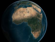
Mapping Africa's Seafloor
A two-part webinar series entitled ‘Mapping the Seafloor around Africa’ was jointly organized by the IOC-UNESCO Sub-Commission for Africa and the Adjacent Island States (IOCAFRICA) and the Nippon Foundation-GEBCO Seabed...
A two-part webinar series entitled ‘Mapping the Seafloor around Africa’ was jointly organized by the IOC-UNESCO Sub-Commission for Africa and the Adjacent Island States (IOCAFRICA) and the Nippon Foundation-GEBCO Seabed...

While there is still lots of ocean mapping work to do on Earth, oceans situated elsewhere in our solar system hold plenty of mysteries too, writes Wim van Wegen in...
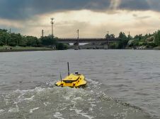
This paper explores the various features of the Apache USV series for efficient seafloor-level mapping. The CHCNAV hydrographic survey software is used for data recording and analysis. It provides results...

Andy Hoggarth’s role at the helm of BD at CARIS is to understand trends in the business space industry as it evolves and to translate these from idea to product....

Schmidt Ocean Institute has come together with The Nippon Foundation-GEBCO Seabed 2030 Project for the joint signing of a Memorandum of Understanding to share all of its collected mapping data...

TCarta Marine, a provider of marine geospatial products, is commercializing a new technique to derive highly accurate shallow-water bathymetry measurements from NASA’s ICESat-2 satellite data. The new methodology is being...

Three new global initiatives for mapping the world’s entire ocean floor have been announced in London at a special conference organised by The Nippon Foundation-GEBCO Seabed 2030 Project, the international...

Teledyne Optech is poised to make an impact at Intergeo during its 45th Anniversary this year with new technologies in airborne, mobile and compact Lidar solutions. The company invites guests to visit its exhibit to...
The remarkable capabilities of airborne Lidar continue to improve, with scanners now able to emit more than a million pulses every second. Although it has never been easier to acquire...

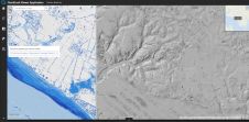
Fugro recently contributed more than 110,000 square kilometres of high-resolution bathymetry data in the North Atlantic Ocean to help improve the quality and coverage of seabed mapping in the region....
This site uses cookies. By continuing to use this website, you agree to our Cookies Policy. Agree