Predicting Dust Storms with Infrared Satellite
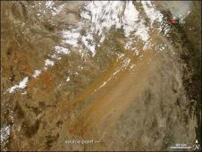
A method for predicting dust and sandstorms using infrared satellite images has been developed by researchers based at the University of Pittsburgh (USA). They can determine when conditions are ripe...
A method for predicting dust and sandstorms using infrared satellite images has been developed by researchers based at the University of Pittsburgh (USA). They can determine when conditions are ripe...
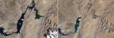
In August 2010, Lake Mead reached its lowest level since 1956. Two images from the Thematic Mapper on the Landsat 5 satellite show some of the stark changes on the...

As part of an ongoing project to bring to city managers, citizens, tourists and others geo-data of the Golden Horn area of Istanbul, Turkey, the authors designed a geo-database accessible...

Snow-covered deserts are rare, but that is exactly what the Moderate Resolution Imaging Spectroradiometer (MODIS) on NASA’s Aqua satellite observed as it passed over the Taklimakan Desert in western China...

European Space Agency (ESA)’s ice mission has been used to create a new gravity map, exposing thousands of previously unchartered ‘seamounts’, ridges and deep ocean structures. This new picture of...

One year on from the biggest UK storm surge for 60 years, new aerial photos have revealed details of breaches to the natural and manmade coastal defences on part of...

Nepal is prone to earthquakes and throughout the centuries the country’s capital city, Kathmandu, has been regularly struck by earthquakes which appear to have similar epicentres and behaviour. The portion...

Caves are important in a wide variety of fields, ranging from construction engineering to mineral exploration and archaeology. Despite the scientific importance of caves, geologists believe that only a relatively...

Australia now has a full suite of new gravity grids at the national scale, being the first publicly released since 2011. The new gravity data adds to the arsenal of...

Structure-from-Motion photogrammetry and GIS are being used to chart the success of a river restoration project in Northern England. Many of the world’s rivers are degraded as a result of...
This site uses cookies. By continuing to use this website, you agree to our Cookies Policy. Agree