Moritz Lauwiner
Moritz Lauwiner is executive vice president and president of the Geomatics division at Hexagon’s Geosystems division. In this role, he oversees research and development, business strategy and overall management of...

Moritz Lauwiner is executive vice president and president of the Geomatics division at Hexagon’s Geosystems division. In this role, he oversees research and development, business strategy and overall management of...

Looking for a recipe for business success in surveying? Don't underestimate the importance of innovative surveying services, says Moritz Lauwiner. The latest measurement sensors and software, decades of collective experience...

The fourth edition of Geo Connect Asia (GCA), celebrated as the region's premier trade event and conference for the geospatial, positioning and remote sensing industries, truly delivered during its two-day...
SimActive has reported that the use of its Correlator3D product along with ground control points can enhance, extend and validate photogrammetry projects. GCPs are critical in photogrammetry projects, but there...

Despite some uncertainty, there is renewed interest in drones, and remote sensing technologies are being embraced by smaller survey companies. Read these and other findings from our annual industry survey!...
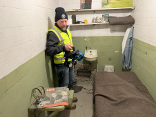
The rugged 22.5-acre site of the notorious US island prison Alcatraz has been digitally captured in a world-leading project involving multiple mapping technologies. With the team camped in the jail’s infamous cells for three weeks during the cold San Francisco winter, this historically, biologically and architecturally important location was recorded in unprecedented 3D detail. We discussed the project with project head Pete Kelsey and team member Dr Jeremy Sofonia. The rugged 22.5-acre site of the notorious US island prison Alcatraz has been digitally captured in a world-leading project involving multiple mapping technologies. With the team camped in the jail’s infamous cells...

Amuse oneself Inc., established in 2011, develops hardware and software for 3D measurements required for ICRT technology (Information, Communication and Robot Technology). Since our successful commercialization of the world’s first...

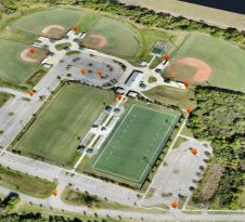
3D visualization is at the heart of many geospatial data applications. Progress in 3D visualization has drastically reduced barriers to entry for new products based on large datasets, thanks to...
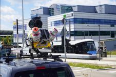
Trimble has recently unveiled the Trimble MX90 mobile mapping system. Integrating advanced Trimble GNSS and inertial technology with Trimble field and office software, the MX90 offers a comprehensive field-to-finish mobile...

Visitor registration is now open for GEO Business, the UK's largest geospatial event. The free-to-attend expo, tailored for geospatial professionals seeking to harness the potential of location intelligence, will return...
This site uses cookies. By continuing to use this website, you agree to our Cookies Policy. Agree