Helicopter Photogrammetry
Surveyors working on busy roads are constantly subjected to close misses from passing traffic; it can be worse. Helicopter photogrammetry is a survey technique designed to prevent fatalities. A complete,...
Surveyors working on busy roads are constantly subjected to close misses from passing traffic; it can be worse. Helicopter photogrammetry is a survey technique designed to prevent fatalities. A complete,...
Applanix (Canada) has announced the appointment of Brad Koziey to the position of director of sales, and Kevin Perkins to the position of executive sales manager, Airborne Products for the...
SmartTech was established in 1996 in Cape Town, South Africa by the current president, Spencer Allen. The company is dedicated to the development of software for surveyors, photogrammetrists and related...
The eighth in the series of annual Map India conferences was organised for the first time this year jointly with the Indian Society of Geomatics (ISG). The event took place...
ADW Software (Belgium) has appointed Western Latitudes (CO, USA) as exclusive Pythagoras distributor in North America. Western Latitudes will promote and sell Pythagoras in the USA. In addition to direct...
The ESRI Survey and GIS Summit 2005 will now include engineering and engineering design tracks and presentations. The summit, taking place 23-26 July 2005, brings professionals together with the goal...
Success often depends on the right combination of factors. Companies are therefore always looking for the right combination to sell their products and make money. Sometimes they succeed, sometimes they...
The XI International GEA 2005 Fair will be held in Poznan, Poland from 15 till 17 September 2005. The highlights are: Spatial Information Systems (GIS): Systems of geographic information for...
Cardinal Systems, LLC, a privately owned company located in Flagler Beach, Florida, USA, was formed in August 2000 when founders Jane Smith and Mike Kitaif joined forces to market their...
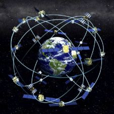
Receiver position is calculated from the position of satellites and the distances to them. Distance is calculated from the time a radio signal travels between satellite and receiver. But how...
This site uses cookies. By continuing to use this website, you agree to our Cookies Policy. Agree