China Increases Urban Planning Efficiency
The China Academy of Urban Planning & Design (CAUPD) recently selected ERDAS APOLLO to manage and deliver its massive amounts of vector and raster data. CAUPD is a scientific research...
The China Academy of Urban Planning & Design (CAUPD) recently selected ERDAS APOLLO to manage and deliver its massive amounts of vector and raster data. CAUPD is a scientific research...
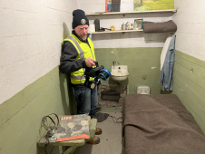
The rugged 22.5-acre site of the notorious US island prison Alcatraz has been digitally captured in a world-leading project involving multiple mapping technologies. With the team camped in the jail’s infamous cells for three weeks during the cold San Francisco winter, this historically, biologically and architecturally important location was recorded in unprecedented 3D detail. We discussed the project with project head Pete Kelsey and team member Dr Jeremy Sofonia. The rugged 22.5-acre site of the notorious US island prison Alcatraz has been digitally captured in a world-leading project involving multiple mapping technologies. With the team camped in the jail’s infamous cells...
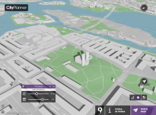
Agency9, known for its technology in large scale streaming and 3D visualisation solutions, announces the release of free global 3D terrain and buildings in CityPlanner – its cloud solution for...

Urban planning has become more complicated due to today’s rate of urbanisation and the rapid expansion of cities. Web-based 3D tools coupled with high-quality 3D city models and digital terrain...

Stockholm Municipality has set up an appealing way of communicating its future urban projects. In the Culture House of Stockholm City, a large touchscreen is available allowing citizens to 'fly'...
Leica Geosystems, part of Hexagon, has launched the Leica TerrainMapper-3 airborne Lidar sensor, featuring new scan pattern configurability to support the widest variety of applications and requirements in a single...
SuperGeo from Taiwan has completed a geographic information system (GIS) for disaster prevention and planning. Located in the Circum-Pacific seismic zone, Taiwan frequently experiences high-magnitude earthquakes throughout the country. Thus,...
Planners and other industry leaders are invited to discuss the impact that social media and the GeoWeb have on their field at the online Spatial Roundtable. ESRI Community Development industry...
This site uses cookies. By continuing to use this website, you agree to our Cookies Policy. Agree