Amuse Oneself
Amuse oneself Inc., established in 2011, develops hardware and software for 3D measurements required for ICRT technology (Information, Communication and Robot Technology). Since our successful commercialization of the world’s first...

Amuse oneself Inc., established in 2011, develops hardware and software for 3D measurements required for ICRT technology (Information, Communication and Robot Technology). Since our successful commercialization of the world’s first...
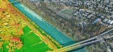
Leica Geosystems, part of Hexagon, has launched the Leica TerrainMapper-3 airborne Lidar sensor, featuring new scan pattern configurability to support the widest variety of applications and requirements in a single...
A team from Greece studied the use of aerial imagery to achieve wide coverage of a predefined geometrical area of interest in a project to explore the contribution of UAVs...
In collaboration with University College London, 3D Laser Mapping will organise its first-ever laser scanning product showcase. There is no charge to attend this event, which will feature the latest...
3D Target has continued to make significant advancements since launching its inaugural Scanfly model at Intergeo in 2016, at a time when Lidar technology in the UAV industry was still...
The technique known as structure from motion (SfM) has been suggested as a valid alternative to traditional photogrammetric methods. In a project in Glasgow, UK, an RTK-based point-to-point validation technique...
The Open Maps For Europe 2 (OME2) project has revealed plans to boost the utilization of European cadastral data. This includes efforts to enhance its discoverability and accessibility. As part...

TatukGIS recently implemented support for geological 3D maps for incorporating multiple, vertically spaced digital elevation models and other layers in the same map project. This was done in response to...

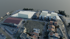
Cliff surveys are traditionally performed with fixed-wing aircraft that collect nadir photos. However, one particular California bluff required the cliff’s face to be surveyed for an erosion study. A photogrammetry...

CHC Navigation provides geospatial professionals with a high-performance, vehicle-independent mobile mapping solution for capturing mass data in constantly evolving global environments. Projects are completed faster and more accurately to increase...
This site uses cookies. By continuing to use this website, you agree to our Cookies Policy. Agree