Topcon bolsters support for Get Kids into Survey
Topcon Positioning Systems has expanded its support for the Get Kids into Survey (GKiS) project, now serving as the exclusive sponsor of the Global Brand Ambassador Hub. This new platform...

Topcon Positioning Systems has expanded its support for the Get Kids into Survey (GKiS) project, now serving as the exclusive sponsor of the Global Brand Ambassador Hub. This new platform...

Join Noah Eckhous from NavVis and Mike Walle from Denn Engineers in downtown Culver City to explore how SLAM-based data capture technology transforms topographic survey workflows. In this video, we...
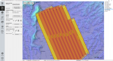
The TatukGIS Developer Kernel (DK) plays a key role in the Topoflight software suite (Missionplanner for optimal flight paths, and Navigator for precise data acquisition). In the realm of vast...
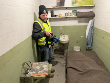
The rugged 22.5-acre site of the notorious US island prison Alcatraz has been digitally captured in a world-leading project involving multiple mapping technologies. With the team camped in the jail’s infamous cells for three weeks during the cold San Francisco winter, this historically, biologically and architecturally important location was recorded in unprecedented 3D detail. We discussed the project with project head Pete Kelsey and team member Dr Jeremy Sofonia. The rugged 22.5-acre site of the notorious US island prison Alcatraz has been digitally captured in a world-leading project involving multiple mapping technologies. With the team camped in the jail’s infamous cells...

3D TARGET was founded as a trading company and official distributor of non-destructive measuring instruments. In 2016, we created an internal R&D division dedicated to system integration and designed a...

Amuse oneself Inc., established in 2011, develops hardware and software for 3D measurements required for ICRT technology (Information, Communication and Robot Technology). Since our successful commercialization of the world’s first...
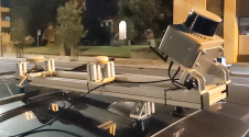
Klau Geomatics has introduced the Brumby RTK Lidar system, an innovative mobile mapping solution equipped with powerful Edge Compute capabilities, enabling the generation of highly precise georeferenced point clouds in...

Calling all professionals! Please contribute to the 2024 edition of the annual geospatial industry survey by GIM International, which is currently in progress. This yearly tradition serves as a valuable...

Trimble has recently unveiled the Trimble MX90 mobile mapping system. Integrating advanced Trimble GNSS and inertial technology with Trimble field and office software, the MX90 offers a comprehensive field-to-finish mobile...
Land Information New Zealand has made 20TB of aerial imagery available for free for the first time in a cloud-optimized format on Amazon Web Services (AWS), making it easier and...
This site uses cookies. By continuing to use this website, you agree to our Cookies Policy. Agree