Berlin gears up for geospatial excellence
As the host city of Intergeo 2023 this October, Berlin promises to deliver the perfect kick-start for the geospatial industry in these rapidly changing times. The vibrant German capital is...

As the host city of Intergeo 2023 this October, Berlin promises to deliver the perfect kick-start for the geospatial industry in these rapidly changing times. The vibrant German capital is...
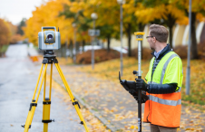
Although the essence of surveying has barely changed since the profession began, the increasingly complex digital continuum requires geospatial professionals to adapt their skills in dynamic and important ways, writes...
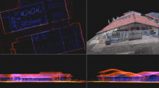
A new partnership marks a significant milestone in the field of reality capture: NavVis has selected Hesai as its exclusive Lidar sensor provider for its industry-leading device, the NavVis VLX...

Ori Cohen is the chief technology officer at Kav Medida Group, a leading national service provider of various mapping products. He is an executive technology leader and commercial pilot with...

HxGN Smart Sites, a real-time data visualization and location intelligence solution for complex site operations such as industrial facilities, airports, hospitals and entertainment venues, has been announced by Hexagon’s Safety,...

In the early days of surveying, surveyors were pioneers in charting the unknown. Today, with the Earth having been completely mapped to some degree, surveying has become a much more...

GEO Business will put the spotlight on geospatial innovation for two days long, from 17-18 May. At ExCeL London, around 3,500 geospatial professionals will come together to discover and debate...

Population growth, urbanization and rapid digitalization all represent global challenges, but they also offer opportunities for the geospatial industry, because reality capture technology is an essential part of the puzzle...

MGISS has signed a partnership agreement with Leica Geosystems to accelerate a data-driven approach to the capture, management and exploitation of asset information. MGISS is a leading UK-based geospatial technology...

We asked James Kavanagh, head of land & resources with The Royal Institution of Chartered Surveyors (RICS), about the challenges facing the geospatial industry, the technological developments that will drive...
This site uses cookies. By continuing to use this website, you agree to our Cookies Policy. Agree