Building a 3D Virtual Forest
A forest management project in Quebec offers the local community a 3D virtual experience of the changes based on GIS data from a Lidar survey, as well as a digital...
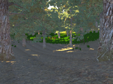
A forest management project in Quebec offers the local community a 3D virtual experience of the changes based on GIS data from a Lidar survey, as well as a digital...

The remarkable capabilities of airborne Lidar continue to improve, with scanners now able to emit more than a million pulses every second. Although it has never been easier to acquire...

An interesting range of new uses for GIS around the world were celebrated at the 38th annual Esri User Conference in San Diego, California, held from 9-13 July. The Esri...
In the following interview with GIS Professional, Satish Sankaran and Chris Andrews speak to Niall Conway about their work on Esri's 'Open Strategy' and about where the GIS industry is...

A spatial data infrastructure (SDI) seeks to harmonise users with the provision of data, metadata, software and computational services to provide a productive and flexible environment for working with geospatial...
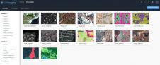
Most image analysis tasks that required ENVI or Erdas Imagine software are now available online thanks to EOS Platform, a new cloud service launched by Earth Observing System (EOS). It...

Pitney Bowes Inc, a global technology company that provides commerce solutions in the areas of e-commerce, shipping, mailing, and data, has announced their continued focus on the user experience through...

In this article, we speak to Paul Ramsey about how both PostgreSQL and PostGIS can provide a solid foundation for any small to large organisational GIS architecture. Paul, a Solutions...

TatukGIS has released the new Developer Kernel for Java edition, a general purpose GIS SDK for vector and raster manipulation, querying, and editing designed for application development using NetBeans, Eclipse,...

Blue Marble Geographics has announced the availability of an update to the Global Mapper Academic Curriculum. Comprised of a series of hands-on lessons, the full package of lab materials is...
This site uses cookies. By continuing to use this website, you agree to our Cookies Policy. Agree