3D geospatial visualization
3D visualization is at the heart of many geospatial data applications. Progress in 3D visualization has drastically reduced barriers to entry for new products based on large datasets, thanks to...

3D visualization is at the heart of many geospatial data applications. Progress in 3D visualization has drastically reduced barriers to entry for new products based on large datasets, thanks to...
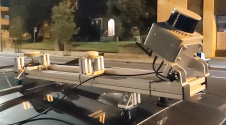
Klau Geomatics has introduced the Brumby RTK Lidar system, an innovative mobile mapping solution equipped with powerful Edge Compute capabilities, enabling the generation of highly precise georeferenced point clouds in...
Blue Marble Geographic’s flagship software, Global Mapper Pro, is an all-in-one GIS package for analysing and processing vector, terrain, image and point cloud data. Compatible with over 380 different file...
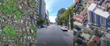
Both vertical and oblique aerial images have their own advantages, making them valuable in different reality mapping applications. So how can you choose between the two? This comparison will help...
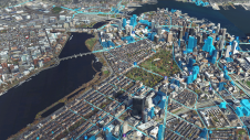
How can city digital twins support the attainment of SDG11? They can be used to manage infrastructures (e.g. roads, transportation and public services, smarter energy grids and water networks), support...
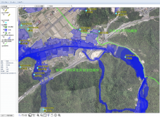
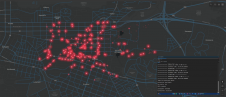
Nestled in the Hiroshima Prefecture of Japan, Higashihiroshima City has unveiled an advanced flood hazard and disaster prevention web GIS application. Powered by the TatukGIS developer kernel (DK) for ASP.NET,...

The integration of geospatial information software (GIS), remote sensing and surveying and mapping data has accelerated in recent years. Meanwhile, new technologies such as AI models and ChatGPT are emerging...
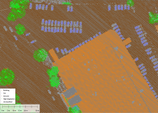
Through the National Registry Center (CNR), the government of El Salvador is embarking on a large-scale project to map the complete country (an area of 20,742km2), with the 14 departmental...
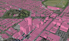
Ecopia AI and Woolpert have expanded their partnership to map Australia’s top metropolitan areas in 3D. The resulting vector maps will provide Woolpert’s Asia-Pacific clients with a detailed, accurate and...
From drones and satellites to airborne-based sensors and Lidar, advances in remote sensing and geospatial information science are driving the development of innovative methods for data acquisition, processing and maintenance....
This site uses cookies. By continuing to use this website, you agree to our Cookies Policy. Agree