Lidar Data Helps Farmers Apply for Carbon Credits
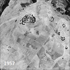
A new project in the UK is using Lidar data to identify areas of hedgerow as the basis for landowners to claim correct levels of carbon credits. The data in...

A new project in the UK is using Lidar data to identify areas of hedgerow as the basis for landowners to claim correct levels of carbon credits. The data in...
Only a small fraction of the information content in aerial films has ever been recorded on paper maps, most of which are inaccessible. The use of artificial intelligence (AI) to...

Data visualization is inherent to humans and continuously evolves, driven by innovation. How is GIS playing a role in this? The term 'data visualization' has come into popular usage relatively...

The role of aerial surveying in the technological response to challenges such as the global pandemic, climate change and societal issues was discussed at the EAASI Partners Summit in Malaga,...

Mathias Disney is a professor in the Department of Geography at University College London in the UK and is also a member of the UK’s National Centre for Earth Observation...
Positioning, in its essence, represents the meticulous process of accurately determining the spatial location of an object concerning a specific framework or datum. This fundamental concept of positioning plays an...
The arrival of unmanned aerial vehicles (UAVs or ‘drones’) has democratized the Lidar market forever. Everyday projects can be flown easier and faster, and sensors are getting lighter, more accurate...

Pavel Bella is a geomorphologist and geographer, associate professor at the Department of Geography, Catholic University in Ružomberok, and head of the Cave Protection Department at the Slovak Caves Administration...

Hydrographic surveying in lakes and canal regions has not been an easy job in the past. Due to a lack of professional and portable surveying equipment and mobile platforms, the...

At Aalto University, research has focused on ways to use 3D city models in the capital region of Finland and on applying new 3D mapping technologies to the modelling of...
This site uses cookies. By continuing to use this website, you agree to our Cookies Policy. Agree