Elijah Ebinne
Elijah Ebinne lectures in advanced surveying and geospatial sciences in the Department of Geoinformatics and Surveying on the University of Nigeria Enugu campus. He has a PhD in Remote Sensing...
Elijah Ebinne lectures in advanced surveying and geospatial sciences in the Department of Geoinformatics and Surveying on the University of Nigeria Enugu campus. He has a PhD in Remote Sensing...
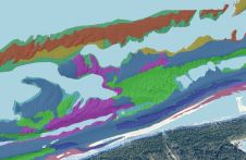
This article presents a novel methodological approach to understand and assess the suitability of airborne Lidar bathymetry for the automatic classification and mapping of the seabed. This solution allows recording of...

Geospatial professionals and land administration experts are invited to take part in the combined FIG C7/C2 Annual Meeting in the historic Hanseatic city of Deventer, the Netherlands. The gathering will...
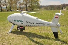
RIEGL Laser Measurement Systems and Schiebel have successfully completed the integration of a high-end laser scanning system, the RIEGL VQ-840-G topobathymetric Lidar sensor, on the Schiebel Camcopter S-100 uncrewed aerial...
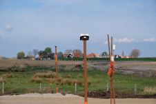
The Locator One solution for autonomous GNSS-based precision measuring has been sold and leased to numerous construction and infrastructure companies, both in the Netherlands and internationally. It was jointly developed...
Operations have commenced at 'Terrabyte' – one of Europe's largest scientific platforms for analysing Earth observation data. It is an initiative of the German Aerospace Centre (DLR) and the Leibniz...
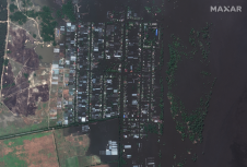
European Space Imaging (EUSI) partner, Maxar collected new high-resolution satellite imagery on 7 June amidst the aftermath of the collapse of the Nova Kakhovka Dam and the widespread flooding along...
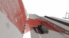
Exploring the complete potential of mobile laser scanning raises the question of whether the obtained results are sufficiently accurate for deformation monitoring. This article focuses on the geometric quality of...
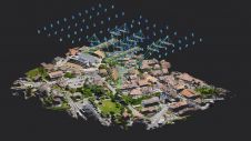
Pix4D has introduced OPF, a new standard for exchanging photogrammetry projects. OPF is a fully open and free specification, enabling the storage and exchange of photogrammetric data among different parties...

Claudio Persello is an adjunct professor at the Faculty of Geo-Information Science and Earth Observation (ITC) of the University of Twente. His main research interests are in the context of...
This site uses cookies. By continuing to use this website, you agree to our Cookies Policy. Agree