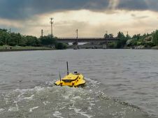
Using the Apache Unmanned Survey Vessel
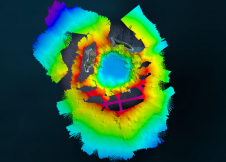
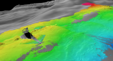
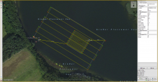
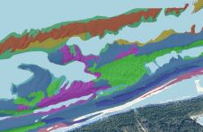
This paper explores the various features of the Apache USV series for efficient seafloor-level mapping. The CHCNAV hydrographic survey software is used for data recording and analysis. It provides results...
This paper explores the various features of the Apache USV series for efficient seafloor-level mapping. The CHCNAV hydrographic survey software is used for data recording and analysis. It provides results...

While there is still lots of ocean mapping work to do on Earth, oceans situated elsewhere in our solar system hold plenty of mysteries too, writes Wim van Wegen in...
RIEGL tested the performance of its topobathymetric airborne laser scanning system in a transition zone context along the French Mediterranean coast. Initially planned as a UAV survey, tests were conducted...
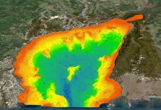
Bathymetric Lidar is a technique that is used to capture geospatial data of coastlines and waterbodies. The method has the potential to facilitate the fast and efficient creation of hydrographic data, and more...
The national land agency in Jamaica has integrated satellite-based hydrography to benefit from time efficiencies, cost savings and improved safety as part of its hydrographic programme in support of the...

Capturing and measuring the environment in the Arctic and Antarctic is a particularly challenging job. The area of interest is often covered by a thick blanket of snow and ice,...
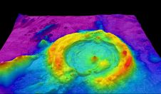
The Tonga Eruption Seabed Mapping Project (TESMaP) is a collaborative mission to discover the undersea impacts of the January 2022 eruption of the Hunga-Tonga Hunga-Ha’apai volcano. Using their collective knowledge,...
The US space agency NASA has successfully pushed the asteroid Dimorphos out of its original orbit in the universe, according to a recent announcement. The space rock was hit 11...
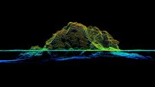
The EvoLogics Multibeam, a new multibeam echosounder option for the Sonobot 5 platform, was released at Ocean Business in Southampton, UK, in April this year. In May, EvoLogics conducted its final trials at one of the company’s regular testing sites the Plessower Lake in Brandenburg, Germany. The company is now taking the Sonobot 5 on a summer demonstration tour for partners and clients so that they can see its efficiency and effectiveness for underwater mapping for themselves. The EvoLogics Multibeam, a new multibeam echosounder option for the Sonobot 5 platform, was released at Ocean Business in Southampton, UK, in April this year. In May, EvoLogics conducted its...
This article presents a novel methodological approach to understand and assess the suitability of airborne Lidar bathymetry for the automatic classification and mapping of the seabed. This solution allows recording of...
This site uses cookies. By continuing to use this website, you agree to our Cookies Policy. Agree