ZZCOMM Technology Co Ltd
Founded in 2017, ZZCOMM technology of geospatial hardware and software solutions provides rapid and high-accurate geospatial data for BIM, mining AEC, survey and mapping industries, whether they are indoor, outdoor,...

Founded in 2017, ZZCOMM technology of geospatial hardware and software solutions provides rapid and high-accurate geospatial data for BIM, mining AEC, survey and mapping industries, whether they are indoor, outdoor,...

Calling all professionals! Please contribute to the 2024 edition of the annual geospatial industry survey by GIM International, which is currently in progress. This yearly tradition serves as a valuable...
Woolpert has secured a contract with the University of Wyoming to generate a digital terrain model and contours. Leveraging Lidar data previously acquired for the United States Geological Survey (USGS),...
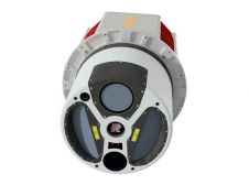
ClearSkies Geomatics, based in Colorado, USA, has recently added the RIEGL VQ-1560 II-S airborne laser scanner to its growing rental system fleet. This laser scanner, an advancement of RIEGL's dual-channel...

Global reference systems such as the International Terrestrial Reference Frame provide the foundation for determining positions on Earth and in space, as well as for reliably quantifying our planet’s changes...

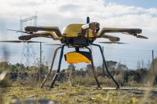
Lidaretto is flexible and compact Lidar scanning system developed since 2015 and uniquely designed to be used the way that fits best to users’ specific application. You can easily mount...
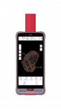
ComNav Technology has introduced its new handheld P6H. This advanced and rugged device is tailor-made for GIS data collection and outdoor operations. Featuring a GNSS high-precision positioning module, rugged IP67-rated...

Less than six months into her term of office, 'GIM International' spoke to Diane Dumashie, president of FIG (2023-2026), to hear about her experiences so far. Here, she shares her...
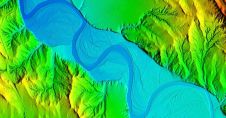
YellowScan, a familiar name in the mapping and land surveying realm, is making a noteworthy entrance in the hydrographic sector with the introduction of its pioneering UAV-based bathymetric Lidar solution....
Trimble has announced a collaboration with the Indian Institute of Technology in Kanpur (IIT Kanpur) to support a new UAV programme offered by the Department of Aerospace Engineering. Trimble's contribution...
This site uses cookies. By continuing to use this website, you agree to our Cookies Policy. Agree