Airborne Lidar Bathymetry
Although operational for more than twenty years, Airborne Lidar Bathymetry (ALB) has rarely been used in riverine areas. The US Bureau of Reclamation adopted it to study how flow change...
Although operational for more than twenty years, Airborne Lidar Bathymetry (ALB) has rarely been used in riverine areas. The US Bureau of Reclamation adopted it to study how flow change...
This article presents a novel methodological approach to understand and assess the suitability of airborne Lidar bathymetry for the automatic classification and mapping of the seabed. This solution allows recording of...

RIEGL has announced the launch of two innovative topobathymetric scanners. These advancements mark a shift towards enhanced efficiency and precision in data collection across land and water interfaces. The RIEGL...
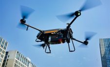
YellowScan, a familiar name in the mapping and land surveying realm, is making a noteworthy entrance in the hydrographic sector with the introduction of its pioneering UAV-based bathymetric Lidar solution....

The arrival of airborne Lidar, also referred to as airborne laser scanning (ALS), has revolutionized area-wide 3D data acquisition of topography, bathymetry, vegetation, buildings and infrastructure. This article presents an...

The traditional sampling protocol for quantifying potential nesting habitat for murrelet requires an observer to peer up through the tree crown from the forest floor, a task resulting in data...
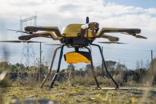
CHC Navigation (CHCNAV) has released the AlphaAir 1400 (AA1400) and AlphaAir 2400 (AA2400) Lidar systems. Both solutions are compact airborne laser scanners that are easily installed on various UAV platforms...
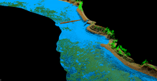
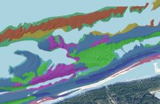
As part of a Catalan government project to improve the management of its marine environment, ICGC cooperated with Field to use airborne Lidar bathymetry (ALB) to survey the Catalan coastal...

The ALS70 family of airborne Lidar systems from Leica Geosystems includes the ALS70-CM City Mapper, ALS70-HP High Performance and ALS70-HA High Altitude models, covering the entire range of Lidar mapping...
This site uses cookies. By continuing to use this website, you agree to our Cookies Policy. Agree