Digital twin of Kaunas stretches from campus to Old Town
The city of Kaunas, Lithuania, is leveraging a digital twin model to help with city planning. This 3D model uses data from the city infrastructure, such as traffic and weather,...

The city of Kaunas, Lithuania, is leveraging a digital twin model to help with city planning. This 3D model uses data from the city infrastructure, such as traffic and weather,...

Hexagon’s Safety, Infrastructure & Geospatial division and Fujitsu Limited have partnered to deliver a digital twin platform for Stuttgart, Germany, to support the city’s urban digital twin project. The Civil...
At the 2022 Year in Infrastructure Conference, Bentley Systems announced new capabilities of its iTwin Platform. This significantly extends the scope and interoperability of infrastructure data that engineering firms and...

At the 2022 Technology Impact Awards in British Colombia, Vancouver International Airport (YVR) recently received the Excellence in Industry Innovation Award from the BC Tech Association. The award-winning project involved...

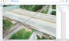
In Germany, an AI-enabled digital twin is being designed to support the country's future railway system. The German rail network is the largest in Western Europe, consisting of 5,700 stations...

Matterport has introduced the all-new Matterport Pro3 Camera along with major updates to its industry-leading digital twin cloud platform. The Pro3 is a breakthrough in 3D capture technology, ready to...

As we enter the era of smart manufacturing, the reliability of data is growing in significance and data standardization is becoming increasingly important. According to JP Kelly, associate director and...

The IoT phenomenon, although still in its infancy, has revolutionised almost every sector in today's world. Among the many buzzwords associated with the field is one known as the 'Digital...

Geo Connect Asia (GCA) is set to return to the Sands Expo and Convention Centre in Singapore on 6 March and 7 March 2024. Since its establishment in 2019, GCA...

EuroGeographics is drawing attention to the indispensable role of official national geospatial data in enhancing Copernicus Services, particularly within land monitoring and emergency management. This highlights a reinforced partnership between...
This site uses cookies. By continuing to use this website, you agree to our Cookies Policy. Agree